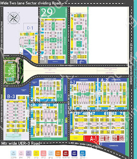
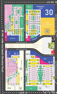
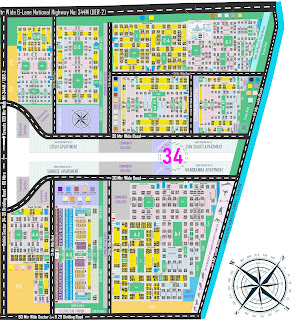
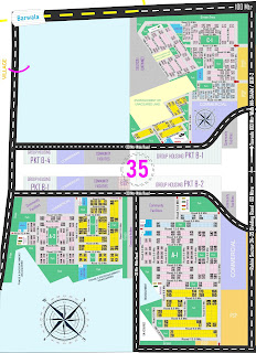
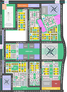
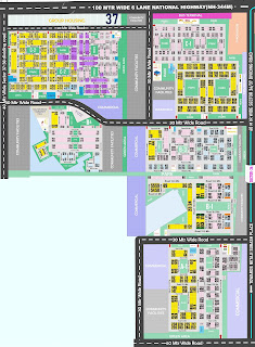
Click on the picture to view the actual big size. blue color plots 26 sq meter size, pink color plots 32 sq meter size, yellow color plots 60 sq meter size, other color plots are alternative plots (big size plots). MB Milk Booth, VB Vegetable Booth, ESS Electric Sub Station , DB Dustbin, Dhalao Dhalao or dustbin, Utility: Shops and other small facilities, Commercial: Land alloted for commercial activities and offices, PSP | CF : Public Semi Public--- Land alloted for Public or Private Club, Hospitals, Schools, colleges, Police stations, Post office etc. IND : Industries , GH : Group Housing Society, Totlot : Children's park,
Here at www.brokerage0.com, we offer 0% brokerage for property sellers(only). And don't worry if you're looking for a property to buy, we have maximum number of properties to satisfy your requirement. Contact WhatsApp 8950508000 for both buy or sell.
PAGE VIEWS
Delhi Rohini Layout Plan Sector 28 29 30 34 35 36 37
Rohini Sector 30 is a compact sector featuring only four pockets. Approximately 30 percent of the area faces encroachment from Prahlad Pur village and the factory area. This sector is bordered by Rohini Sector 28 in the east, separated by Urban Extension Road 3, Rohini Sector 35 in the west, Prahlad Pur village in the south, and Rohini Sector 29 in the north. Rohini Sector 30 offers three types of plots (26, 32, and 60 square meters). Its proximity to Prahlad Pur village and the factory area contributes to relatively lower property prices. An advantageous aspect of this sector is its location on the proposed Urban Extension Road 3, enhancing connectivity. Two well-developed district parks in Rohini Sectors 29 and 30, crafted by the DDA, serve as major attractions. Considerable land is allocated for educational institutions, offices, and commercial areas. While essential amenities like water, electricity, roads, and sewer facilities are already in place, it is estimated to take around 8 to 10 more years for substantial public settlement. Currently resembling a semi-wilderness, it unfortunately attracts unsavory elements. Transportation facilities are lacking, necessitating personal vehicles. Vital services such as schools, colleges, offices, police stations, hospitals, and banks are notably absent and will likely take considerable time to be established. It is crucial to exercise caution and thorough verification before considering plots in the A-2 pocket of Rohini Sector 30, as many are entangled in legal disputes involving factories and village areas.
Both Rohini Sectors 34 and 35 are positioned along the 100-meter-wide 6-lane Urban Extension Road-2, separated by a 60-meter-wide road. They cater to the soaring demand for residential spaces by offering plots of various sizes at economical rates. Rohini Sector-34 is thoughtfully planned and furnished with contemporary amenities. Situated in the northwest corner of Rohini, it is encircled by key sectors such as 29, 30, and 35, the Bawana industrial area, and the upcoming Zone N. This sector is a comprehensive package, appealing to individuals from the lower, middle, and higher socioeconomic classes. It promises to fulfill all expectations of a quality living environment, including schools, hospitals, shopping malls, parks, children's play areas, and expansive roads. Notably, this sector is not adjacent to any village or unauthorized local colony. In terms of population density, Sector 34 is still in its initial stages of development, with much of the area remaining vacant except for a few families residing in society flats allotted in 2014 under the DDA Housing scheme. However, the group housing project faced setbacks due to the compact sizes of the flats, leading to withdrawals by most allottees. Currently, only a handful of families reside in society flats, marking it as the sole area with noticeable habitation. Concerning plotted properties, the entire designated area remains undeveloped, with no construction on the plots as yet. Transportation facilities are nonexistent, necessitating the ownership of a personal vehicle for accessibility. Plots pockets are A1,a2,a3,a4 and c1,c2,c3,c4,c5,c6
Rohini Sector 35 is situated along the 100-meter-wide Urban Extension Road (UER)-2. Despite being a relatively small sector with only three pockets (A1, A2, and C1), it holds substantial investment potential. Approximately 40% of the land in Sector 35 comprises Barwala village and Jain Nagar colony, both long-established unauthorized colonies in Delhi. The plotting of Sector-35 involved acquiring vast farming land from local farmers. Currently in its early stages of development, Sector 35 presents a lucrative investment opportunity, especially with the upcoming Zone N of DDA, the proposed Delhi Metro station, and the transformation of Urban Extension Road-2 into a six-lane national highway. With only three pockets, the sector is expected to have a lower population density. It is poised to offer comprehensive developments akin to existing sectors in Rohini but with additional facilities and amenities. Presently, the sector remains largely vacant, with only a few individuals residing in group housing societies. Its location is strategically surrounded by a 60-meter-wide road to the north, a 60-meter-wide road to the south, a 100-meter-wide road to the west, and a 60-meter-wide road to the east. Additionally, Sector 35 is bordered by Sector 36 to the south, Sector 30 to the east, Sector 34 to the north, and the upcoming Zone N of DDA. The presence of wide roads contributes to excellent connectivity, with 9, 12, and 30-meter roads within the sector.
Rohini Sector-36 stands as an enticing investment opportunity, a prime residential choice, and a hallmark of excellence set to become the epitome of fine living. Positioned in the western corner of Rohini, this sector is currently in its early stages of development. Sectors 36 and 37 share an eastern location alongside UER-2 road, with a demarcation by the Silk road of Rohini, a 60-meter-wide thoroughfare. Renowned for its potential for investment and luxury living, Sector 36 holds a strategic advantage due to its location on the connecting road from Netaji Subhash Place (NSP) to the Heliport of Rohini Sector 36. The existing Delhi Metro, reaching till Rithala, is anticipated to extend its route to connect Sector 31, 32, 36, and 37 in the future, aligning with the route from NSP to Rohini Sector-36's Heliport road. Another notable factor is the sector's surroundings, encompassed by various sectors of Rohini and adjacent to the small unauthorized colony, Barwala village. Sector 36 comprises seven pockets (A1, A2, A3, B1, C1, C2, C3). Pockets A1, A2, A3, and B3 are deemed favorable for investment and residence, commanding higher prices due to their superior locations compared to other pockets. Conversely, the prices of pocket C1 and C2 are relatively lower, influenced by the proximity of pocket C1 to Barwala village and a cemetery situated between C1 and C2, contributing to lower property values. Pocket C3 features plots with a uniform size of 60 meters, and several plots of 26 and 32 meters have been canceled.
Rohini Sector 37 is strategically positioned in Rohini, bordered by UER-2 to the west, Sector-32 to the east, Sector-36 to the north, and encroached upon by the Tamatar colony of Begumpur (an unauthorized colony) to the south. This sector presents a blend of residential plots and a group housing society, offering three plot sizes (26, 32, and 60 meters) available for resale. Situated on the east side of the UER-2 road, Sector 36 and Sector 37 share the same location, distinguished by the 60-meter-wide Silk Road in Rohini. Noteworthy factors such as the Silk Road of Rohini, the ongoing construction of a large bus terminal, Urban Extension Road (UER-2), the upcoming Zone N city, and the proposed metro project contribute to establishing this sector's excellent location. It is poised to be well-equipped with essential facilities including parks, multi-level parking, shopping complexes, milk and vegetable booths, hospitals, schools, police stations, community facilities, and colleges. Although currently unoccupied due to its early stage of development, forms were filled in 1981, and plots were allotted in 2018 by the DDA. After 40 years, this sector is now ready for habitation, albeit still vacant. A few property agents have established their plots for business purposes. Development is anticipated to commence with the proposed Delhi Metro's work on the Rithala, Bawana, and Narela lines. Resale options are the only available properties, with limited plots in this sector. The sector's prime location, precisely on the Netaji Subhash Place and Rithala Metro road, where the Delhi Metro's Metro Lite project is proposed, renders it a compelling investment. Upcoming projects like DDA's Zone N, the Silk Road of Rohini, the bus terminal, and the proposed Delhi Metro are expected to enhance the sector's value and prices.
Subscribe to:
Comments (Atom)

%20copy.jpg)
